What Are the States That Are in Tornado Alley?
If you’ve searched what are the states that are in Tornado Alley, you’ve probably seen different answers depending on the source. That’s because Tornado Alley is not an official government region with fixed borders. Instead, it’s a meteorological term used to describe areas of the United States that experience a high frequency of tornadoes, especially strong and violent ones.
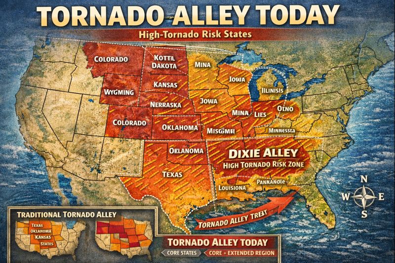
Over the last decade, tornado data has shown that Tornado Alley is evolving. While the central Plains remain the core of tornado activity, risk has expanded outward and now overlaps with regions like Dixie Alley in the Southeast. Understanding where Tornado Alley is located today is critical for homeowners, families, and anyone making safety or relocation decisions.
This guide provides a clear, updated explanation of what states are in Tornado Alley, why maps differ, how the region has changed, and what this means for tornado preparedness in 2025 and beyond.
What Defines Tornado Alley?
Tornado Alley refers to areas where atmospheric conditions frequently combine to create tornado-producing thunderstorms. These conditions include:
- Warm, moist air flowing north from the Gulf of Mexico
- Cold, dry air moving south from Canada or the Rocky Mountains
- Strong jet stream winds creating wind shear
- Flat or gently rolling terrain that supports storm development
When these elements align, supercell thunderstorms can form, producing tornadoes that range from weak to violent EF4 and EF5 events.
Because these ingredients don’t respect state borders, Tornado Alley is defined by tornado frequency and intensity, not political boundaries. That’s why a Tornado Alley map USA can look slightly different depending on the data used.
Core States in Tornado Alley
Based on long-term tornado records, meteorological research, and historical storm patterns, the following states are considered the core of Tornado Alley. These states consistently experience the highest number of strong and violent tornadoes.
Core Tornado Alley States
- Texas (especially North and Central Texas)
- Oklahoma
- Kansas
- Nebraska
- South Dakota
- Iowa
When people ask what states are considered Tornado Alley, these six are almost always included. The region sees peak activity in spring and early summer, though tornadoes can occur outside those months as well.
Texas deserves special mention. Searches like Tornado Alley Texas are common because Texas records more tornadoes than any other state, largely due to its size and geography. North Texas sits squarely in the heart of Tornado Alley.
Extended and Overlapping Tornado Alley States
Modern tornado data shows that tornado risk doesn’t stop at the core states. Several surrounding states experience frequent tornadoes and are often included on updated Tornado Alley states maps.
Extended or Overlapping States
- Missouri
- Illinois
- Indiana
- Ohio
- Colorado (eastern plains)
- Minnesota
These states may not see the same tornado density as Oklahoma or Kansas, but they regularly experience damaging tornadoes, especially during peak storm seasons. This is why some sources list more than just the traditional core when answering all states in Tornado Alley.
Where Is Tornado Alley in the United States Today?
If you’re wondering where is Tornado Alley in the United States, the most accurate answer is that it stretches from the southern Plains northward into the Midwest, with blurred edges rather than hard lines.
A modern Tornado Alley map USA typically shows:
- The highest risk concentrated in Texas, Oklahoma, and Kansas
- Significant risk extending into the Midwest
- Overlap with the Southeast, often labeled as Dixie Alley
This overlap is why questions like where is Tornado Alley 2025 are becoming more common. Tornado risk is no longer confined to one narrow corridor.
Tornado Alley vs Dixie Alley
One reason for confusion around Tornado Alley states is the rise of Dixie Alley in the Southeast. While Tornado Alley and Dixie Alley overlap, they are not the same.
Tornado Alley Characteristics
- More daytime tornadoes
- Better visibility due to open terrain
- Longer historical warning times
Dixie Alley Characteristics
- More nighttime tornadoes
- Rain-wrapped storms with poor visibility
- Higher population density
- Higher fatality rates per tornado
States like Alabama and Mississippi experience frequent tornadoes, but they are usually classified as part of Dixie Alley rather than traditional Tornado Alley. This distinction matters because the risks and preparedness needs are different.
Why Tornado Alley Maps Keep Changing
Many people notice that Tornado Alley maps look different from one source to another. This happens because:
- Climate and jet stream patterns are shifting
- Gulf moisture is influencing storms farther east
- Tornado detection and reporting have improved
- Population growth increases recorded impacts
As a result, newer maps emphasize risk and impact, not just tornado counts. This is why some states appear on newer Tornado Alley states maps even if they weren’t traditionally included.
What This Means for Homeowners and Families
If you live in any of the states listed above, tornado preparedness should be part of your household safety plan.
Many homes in Tornado Alley states:
- Do not have basements
- Are built on slab foundations
- Have limited safe interior spaces for extreme tornadoes
Interior rooms can help, but they are not engineered to withstand direct tornado impacts. That’s why more families are choosing FEMA-rated storm shelters for reliable protection.
Companies like Steadfast Storm Shelters design shelters specifically for high-risk tornado regions. Their residential options are built to withstand extreme winds and debris impacts common in Tornado Alley.
You can explore protection options here:
- Steadfast Storm Shelters
- Residential Above-Ground Shelters
- Steel Safe Rooms
- Concrete Storm Shelters
- Residential Underground Shelters
Summary: What Are the States That Are in Tornado Alley?
To clearly answer the question what are the states that are in Tornado Alley, here is the most accurate breakdown today.
Core Tornado Alley States
- Texas
- Oklahoma
- Kansas
- Nebraska
- South Dakota
- Iowa
Extended or Overlapping States
- Missouri
- Illinois
- Indiana
- Ohio
- Colorado (eastern plains)
- Minnesota
Tornado risk also extends into Dixie Alley in the Southeast, reinforcing that preparedness should not stop at traditional labels.
Tornado Alley FAQs
What states are in Tornado Alley?
Core states include Texas, Oklahoma, Kansas, Nebraska, South Dakota, and Iowa, with several surrounding states experiencing significant tornado risk.
Is Tornado Alley officially defined?
No. It is a meteorological term, not a legal or government-defined region.
Is Tornado Alley shifting east?
Risk is expanding and overlapping with Dixie Alley, especially in the Southeast.
Which state has the most tornadoes?
Texas typically records the highest number due to its size and geography.
Do people in Tornado Alley need storm shelters?
Yes. FEMA-rated storm shelters provide the highest level of protection in high-risk tornado regions.
Understanding what states are in Tornado Alley helps families make informed decisions about safety, housing, and preparedness. As tornado patterns evolve, staying informed and prepared is no longer optional. It’s essential.
