Dixie Alley Map Explained: Why Tornado Risk Is Rising in the Southeast
For decades, most Americans associated tornadoes with the Great Plains. When people thought about severe weather, they pictured wide-open farmland, towering supercells, and the traditional Tornado Alley stretching through the Midwest. Today, the Dixie Alley map tells a very different story. Tornado risk in the southeastern United States is not only real, it is growing, and in many cases, it is more dangerous than in the Plains.
Communities across Alabama, Mississippi, Tennessee, Georgia, and surrounding states now experience frequent and often deadly tornado outbreaks. These storms tend to strike at night, hide inside heavy rain, and move through densely populated areas with limited warning. The result is higher injury and fatality rates, even when tornadoes are not the strongest on record.
If you have searched for a Dixie Alley map and wondered what it really means, where Dixie Alley is located, or how it compares to Tornado Alley, this guide breaks it all down. You will learn what Dixie Alley is, why tornado risk is increasing in the Southeast, which states are most affected, and what this means for homeowners and families across the United States.
What Is Dixie Alley?
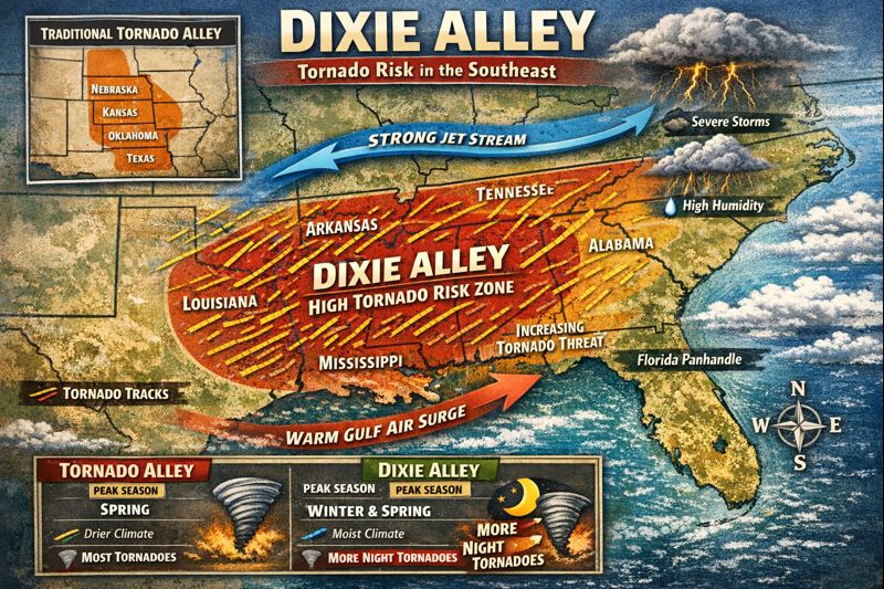
Dixie Alley is a term used by meteorologists and researchers to describe a region of the southeastern United States that experiences a high concentration of tornadoes and tornado-related fatalities. Unlike Tornado Alley, which is defined largely by storm frequency, Dixie Alley is identified by a combination of storm activity, population exposure, and impact severity.
So when people ask, what is Dixie Alley, the answer goes beyond simple geography. It is not just where tornadoes occur, but where they are most dangerous.
A typical map of Dixie Alley includes:
- Alabama
- Mississippi
- Tennessee
- Georgia
- Arkansas
- Louisiana
- Parts of North Carolina and South Carolina
The boundaries are not fixed. Different studies may include or exclude certain areas based on tornado density, historical tracks, or fatality data. What remains consistent is that the Southeast experiences a unique and elevated tornado risk.
Where Is Dixie Alley Located?
If you are asking where is Dixie Alley located, the simplest answer is the Deep South and parts of the lower Southeast. The region sits east of traditional Tornado Alley and south of the Ohio Valley.
Geographically, Dixie Alley overlaps with:
- The Gulf Coast moisture corridor
- Heavily forested landscapes
- Regions with rolling hills and limited visibility
This location places Dixie Alley directly in the path of warm, moist air from the Gulf of Mexico colliding with cooler air from the north and west. That collision fuels powerful thunderstorms capable of producing tornadoes.
A Dixie Alley map visually highlights this corridor of risk, showing why tornadoes in this region are not isolated events but part of a recurring pattern.
Dixie Alley States at Highest Risk
When people search for Dixie Alley states, they are often trying to determine whether their home or community falls within this high-risk zone.
The states most commonly associated with Dixie Alley include:
- Alabama
- Mississippi
- Tennessee
- Georgia
- Arkansas
- Louisiana
Parts of the Carolinas are increasingly included as tornado activity shifts eastward. These states consistently appear on Dixie Alley maps because they experience:
- High tornado frequency
- Strong tornado intensity
- Increased fatalities per event
Alabama and Mississippi, in particular, often rank at the top for tornado-related deaths nationwide.
Dixie Alley vs Tornado Alley: What’s the Difference?
The comparison between Tornado Alley and Dixie Alley is critical for understanding risk. While both regions face severe weather, they are dangerous in different ways.
Traditional Tornado Alley
Tornado Alley typically includes states like Oklahoma, Kansas, Nebraska, and northern Texas. Tornadoes here are often:
- More visible
- Occurring during daylight hours
- Forming over flat, open terrain
Because storms are easier to see and track, warning effectiveness tends to be higher.
Dixie Alley
Dixie Alley tornadoes present greater human risk because:
- Storms are often rain-wrapped and hard to see
- Tornadoes frequently strike at night
- Dense tree cover limits visibility
- Population density is higher
- Many homes lack basements
Even when wind speeds are similar, tornadoes in Dixie Alley are more likely to cause injuries and fatalities. The Dixie Alley map reflects this by emphasizing impact, not just storm counts.
Why Tornado Risk Is Rising in Dixie Alley
The increasing prominence of the Dixie Alley map is not accidental. Several factors are driving higher tornado risk in the Southeast.
Warmer Gulf of Mexico Waters
The Gulf of Mexico is a primary fuel source for severe weather. Warmer waters increase moisture and atmospheric instability, which supports stronger and more frequent supercell thunderstorms.
Year-Round Tornado Potential
Unlike Tornado Alley, which peaks in spring, Dixie Alley experiences tornadoes in multiple seasons, including winter. This leads to:
- Lower public preparedness
- Fewer drills and reminders
- Higher surprise factor
Nighttime Tornadoes
A significant portion of Dixie Alley tornadoes occur after dark. Nighttime events reduce visibility, delay reaction times, and increase danger for sleeping families.
Increased Population Exposure
More people are living in high-risk areas, often in homes built on slab foundations without basements. As development expands, tornadoes affect more structures and lives.
All of these factors are visible on a modern Dixie Alley map, which shows not just where tornadoes form, but where they cause the most harm.
What the Dixie Alley Map Tells Homeowners
For homeowners, the Dixie Alley map is a warning signal. It shows that traditional tornado safety assumptions may not be enough.
In many Dixie Alley communities:
- Basements are rare or nonexistent
- Soil conditions limit underground construction
- Warning times can be short
- Interior rooms may not provide adequate protection
This reality has led many families to reconsider how they prepare for severe weather.
Tornado Safety Challenges in the Southeast
Tornado safety strategies developed for the Midwest do not always translate well to Dixie Alley.
Common challenges include:
- Heavy rain that hides tornadoes
- Trees that block sightlines
- Fast-moving storms with limited lead time
- Mobile homes and older housing stock
These challenges help explain why Dixie Alley tornado fatality rates remain high. A Dixie Alley map does not just show storm paths, it highlights where traditional safety measures fall short.
Why Storm Shelters Are Becoming Essential in Dixie Alley
As awareness of Dixie Alley grows, so does interest in storm shelters. Properly designed shelters provide protection that interior rooms cannot.
FEMA-rated storm shelters are engineered to withstand:
- EF4 and EF5 wind speeds
- High-velocity debris impacts
- Structural collapse of nearby buildings
In the Southeast, above-ground shelters are often preferred due to soil conditions and accessibility needs. Homeowners increasingly explore options like residential above-ground shelters, steel safe rooms, concrete shelters, and residential underground shelters depending on property layout and risk tolerance.
Companies such as Steadfast Storm Shelters focus on solutions built specifically for the realities of Dixie Alley. Regional expertise matters when storm behavior differs from the Plains.
You can explore shelter options directly through:
- Steadfast Storm Shelters
- Residential Above-Ground Shelters
- Steel Safe Rooms
- Concrete Storm Shelters
- Residential Underground Shelters
Common Myths About Dixie Alley Tornadoes
Several misconceptions persist despite what the Dixie Alley map clearly shows.
Myth: Tornado Risk Is Moving Away From Tornado Alley
Reality: Risk is expanding, not relocating. Both regions face serious threats.
Myth: Only Strong Tornadoes Are Deadly
Reality: In Dixie Alley, even EF2 or EF3 tornadoes can be deadly due to timing and visibility.
Myth: Interior Rooms Are Always Enough
Reality: For stronger storms, interior rooms may not provide adequate protection.
The Dixie Alley map helps correct these myths by emphasizing real-world outcomes.
What Families in Dixie Alley Should Do Next
Understanding where you live on the Dixie Alley map is only the first step. Action saves lives.
Families in high-risk areas should:
- Identify shelter options in advance
- Monitor weather alerts year-round
- Practice tornado safety plans
- Consider installing a FEMA-rated storm shelter
Preparedness matters more in Dixie Alley because storms often leave little time to react.
How the Dixie Alley Map Is Used by Experts
Meteorologists, emergency managers, and researchers use Dixie Alley maps to:
- Identify high-risk communities
- Improve warning systems
- Plan emergency response resources
- Educate the public on evolving risk
These maps are updated as weather patterns shift and data improves, making them essential tools for long-term planning.
The Future of Tornado Risk in the Southeast
Climate trends suggest that tornado activity in the Southeast may continue to increase or remain elevated. While no single factor explains all changes, warmer temperatures and shifting storm tracks are expected to keep Dixie Alley relevant for years to come.
For homeowners, this means:
- Tornado preparedness is no longer optional
- Risk awareness must extend beyond spring
- Structural protection will play a larger role in safety
The Dixie Alley map is not a forecast. It is a reflection of patterns already underway.
Dixie Alley Map FAQs
What is the Dixie Alley map?
It is a visual representation of tornado risk concentrated in the southeastern United States, highlighting frequency and impact.
Is Dixie Alley more dangerous than Tornado Alley?
In many cases, yes. Dixie Alley tornadoes cause higher fatality rates due to nighttime storms, rain, and population density.
Where is Dixie Alley located?
Primarily in the southeastern U.S., including Alabama, Mississippi, Tennessee, Georgia, Arkansas, Louisiana, and parts of the Carolinas.
Why are tornadoes increasing in Dixie Alley?
Warmer Gulf moisture, shifting weather patterns, and increased development all contribute.
Do people in Dixie Alley need storm shelters?
Given the risk profile shown on the Dixie Alley map, FEMA-rated storm shelters are strongly recommended for reliable protection.
Final Thoughts: Why the Dixie Alley Map Matters
The Dixie Alley map changes how we think about tornado risk in the United States. It shows that danger is not confined to the Plains and that the Southeast faces unique challenges that demand new approaches to safety.
By understanding where Dixie Alley is located, how it differs from Tornado Alley, and why tornado risk is rising, families can make informed decisions that protect lives. Awareness is the first step. Preparedness is the next.
In Dixie Alley, preparation is not fear-driven. It is a practical response to a documented and growing risk.

